|
Medinet Habu & the Temple
of Ramesses III
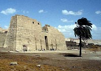 The entire Temple of Ramesses III, palace and town is enclosed
within a defensive wall. The entire Temple of Ramesses III, palace and town is enclosed
within a defensive wall.
Entry is through the Highgate, or Migdol, which, in appearance
resembles an Asiatic fort.
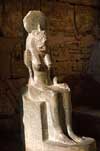
Just inside the Highgate, to the south, are the chapels of
Amenirdis I, Shepenwepet II and Nitoket, wives of the god Amun.
To the north side is the chapel of Amun. These chapels were a
later addition dating to the 18th Dynasties, by Hatsepsut and
Tutmose II. Later renovations were done by the Ptolemaic kings
of the XXV Dynasty.
 To the west is the temple proper, which was styled after the
Ramesseum. To the west is the temple proper, which was styled after the
Ramesseum.
On the north wall of the temple are reliefs depicting the
victory of Ramesses with the Sardinians, Cretans, Philistines
and the Danu. This was perhaps the greatest victory in ancient
Egypt. These are the only known reliefs of a sea battle in
Egypt.
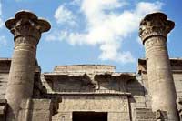
Entering through the massive Pylon (27m high and 65m long) is
the First Court where athletic sporting events, such as
wrestling, were held. Reliefs on the south wall are of Ramesses'
victory over the Libyans and the Window of Appearances is on the
west wall, flanked by eight columns.
On the east side are seven Osiride pillars.
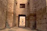 The Second Court, accessed via ramp up and through the Pylon, is
made up of eight Osiride pillars and six columns. Of the scenes
in the Second Court are the Feast of Sokar and the lower part of
the back wall being dedicated to Ramesses children. The Second Court, accessed via ramp up and through the Pylon, is
made up of eight Osiride pillars and six columns. Of the scenes
in the Second Court are the Feast of Sokar and the lower part of
the back wall being dedicated to Ramesses children.
Of interest in the entrance at the right end of the hall is a
relief of Ramesses kneeling on the symbol of Upper and Lower
Egypt and a defaced scene of Ramesses before Seth, with the
Pharaoh changed into Horus.
The Hypostyle Hall through the west entrance was badly damaged
in 27 B.C. by an earthquake. Originally, The Hall would have
opened into many rooms but none remain due to the earthquake.
 Close to the temple is the remains of a Nilometer. Close to the temple is the remains of a Nilometer.
These 'flood warnings' were positioned strategically along the
river to determine the position of the river every year. Not
only did these register the height of the river, but also
determined the amount of silt that was being deposited.
With this information, the governors could, in advance,
determine which crop would thrive and thus base the tax levy. |